
Ready to Hike Iceland’s Laugavegur Trail? Planning a 4-Day Adventure
By: Sarah Stone
Skip to Section
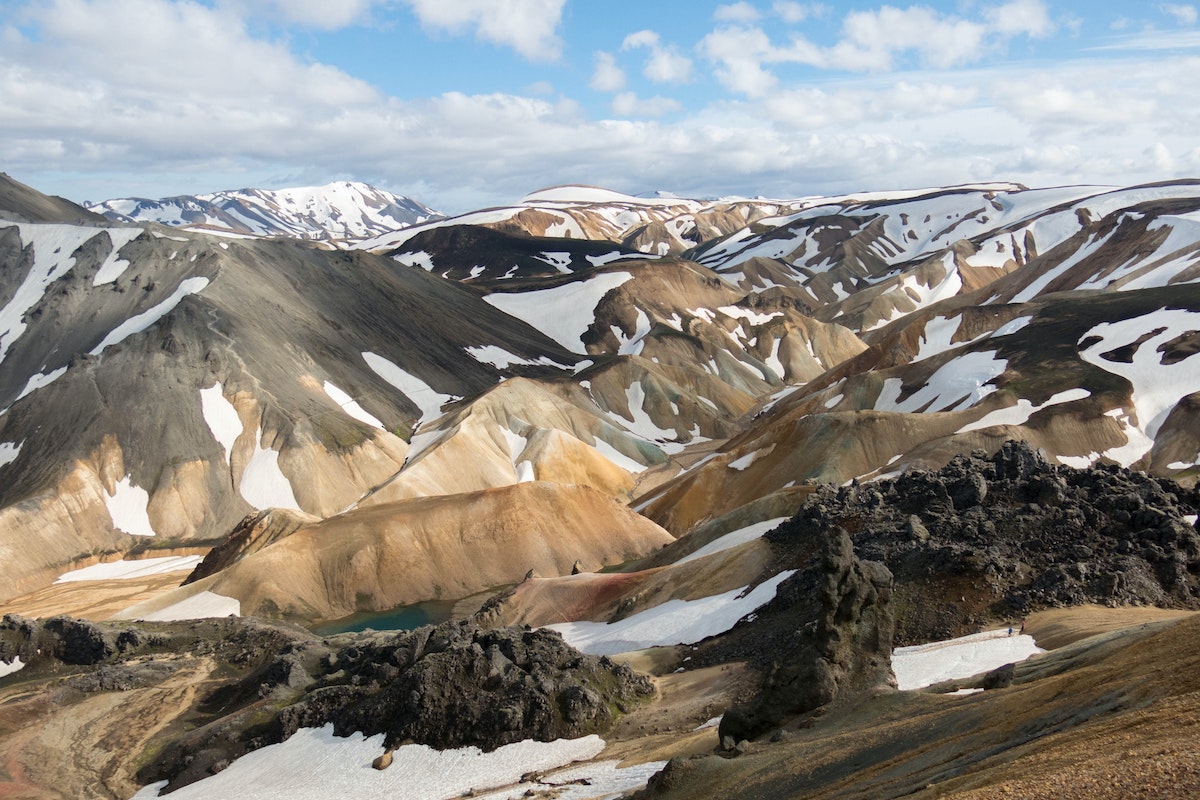
Based in the southern Icelandic highlands, the Laugavegur Trail spans about 34 miles (about 55 km) from Landmannalaugar to Thórsmörk. With black sand fields, colorful mountains, lush vegetation, glaciers, and hot springs, it’s easy to see why this was named one of the world’s 20 best hiking trails by National Geographic.
If your dream is to hike the world famous Laugavegur Trail, read on!
Planning to Hike the Laugavegur Trail
The Laugavegur Trail is only open during the summer, from about mid-June to early September. Outside of that timeframe, the weather can be too dangerous for hikers. Even with more favorable conditions, the Icelandic weather can still be unpredictable, so you’ll want to be well prepared for rain, snow, sunshine, and wind.
Most travelers spend about four days and three nights hiking the Laugavegur—we’ll provide an example itinerary in the next section.
You don’t need a permit to hike the trail, but you will of course want to plan your trip well in advance. The hike is moderate to difficult, and you should be in good enough shape to walk about 12—15 km per day, with some river crossings as well as a few areas of the trail being quite steep.
You can bring a tent and camp out each night, or stay in one of the huts along different checkpoints—you will need to book your spot in the hut a few months in advance, as these fill up very quickly. If you’re RV’ing, booking your campervan well in advance will give you peace of mind along your journey.
- Huts: The huts along the trail are basic but comfortable, with shared sleeping quarters of bunk beds as well as mattresses placed on the floor. There’s a shared kitchen and running water (you’ll need to bring your own meals, as food is not served here), and there are toilets in a separate building. The average price per person to stay in a hut for one night is 10,200 ISK (about $72 USD).
- Campgrounds: Campgrounds, meanwhile, are also located near the huts and don’t need to be booked in advance—here, you’ll have access to drinking water, toilet facilities, and small shops. The trail can get quite rainy and windy, so you may want to take this into consideration while planning your trip. The average camping price per night is 2,500 ISK (about $18 USD) per person.
As you start to plan your packing list, keep these tips in mind:

- Food: Take along whatever food you need for the days you’ll be on the trail, plus a little extra in case the weather or other factors slow you down a bit. You can pick up some essentials at the beginning of the trail, and if needed, there may be some snacks available at the huts along the way, though you shouldn’t depend on these!
- Layers: Bring layers because the weather can change quickly—it’s good to have waterproof gear in particular for sudden rains, as well as for river crossings. It also gets very windy here, and when the temperature drops, having too few layers can be dangerous.
- Boots: Don’t use this time to break in a new pair of hiking boots—bring boots that you’re comfortable wearing and that you know you can handle in snow, rocky terrain, and steep inclines and descents. You may also wish to bring lightweight sneakers for the river crossings, rather than wearing your boots and taking extra time to dry them out. And of course, pack extra socks!
Other items to bring along include:
- Camping Gear: Basic gear should include your tent (if you’re not staying in a hut each night), sleeping bag and sleeping pad, stove, and cooking utensils.
- Hiking Gear: You should remember to bring a multitool, first aid kit, water bladder, trekking poles (recommended for the final descent in particular), headlamp, dry bags, toilet paper, sunscreen, and soap.
- Other Gear: In addition to the basics, you’ll want to have a guidebook, your phone, an adapter and charger, extra batteries, and a GPS. While the trail is clearly marked (with markers about every 200 m) you don’t want to chance getting turned around or lost.
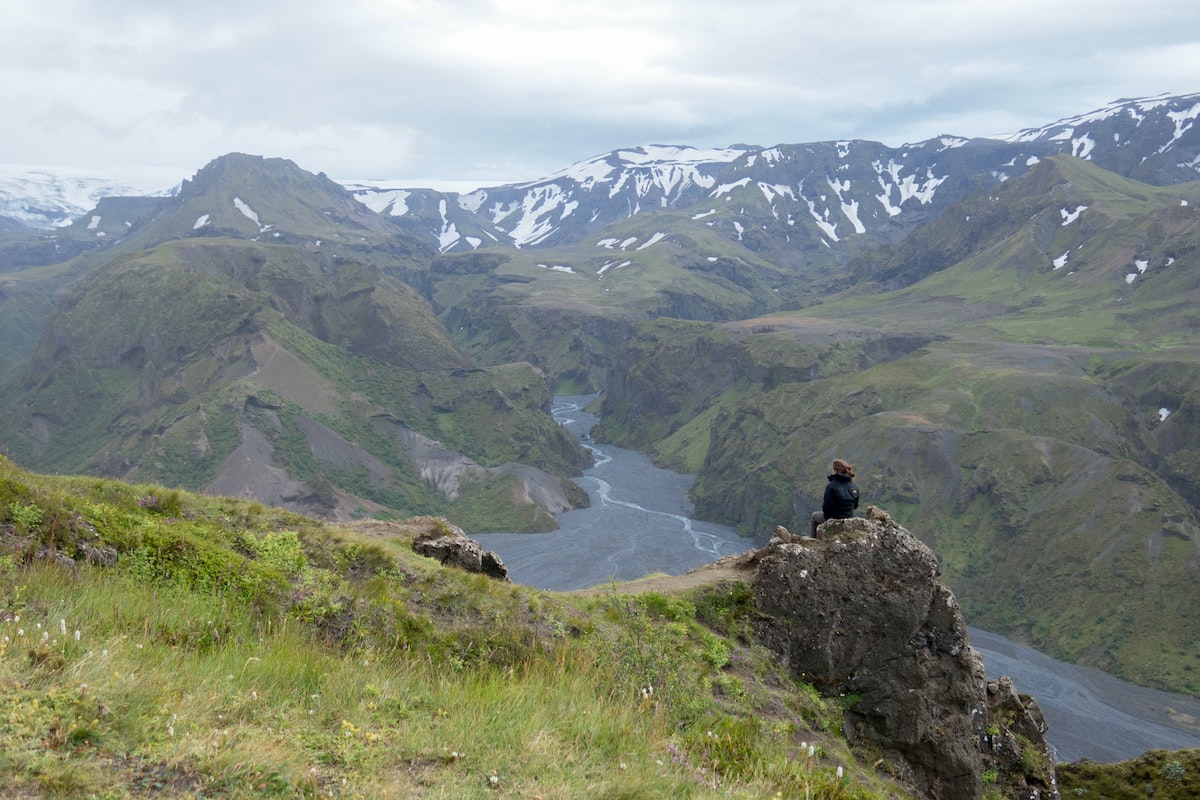
Photo by Philip Lindberg on Unsplash
Sample Itinerary for Hiking the Laugavegur Trail
You can travel solo or with a group while hiking the Laugavegur Trail (plus there are companies that you can sign up with to go on a guided hike), and the itinerary below reflects the most common route that travelers take.
Most hikers choose the north-south route, from Landmannalaugar to Thórsmörk, which is mostly downhill. There are other trails branching off from Thórsmörk as well, if you’d like to extend your trip. To start though, you’ll take a highland bus to the trailhead where you can pick up some final essentials and be on your way!
Day 1: Landmannalaugar to Hrafntinnusker
For your first day, you’ll hike 12 kilometers, or a little over seven miles. You’ll see colorful mountains composed of rhyolite, a volcanic rock—and as you progress, the trail will lead you to a plateau in a volcanic caldera with hot springs and geothermal vents. Even though it’s summer, you may find yourself hiking through snow, which can slow you down a bit. At the end of the day, you’ll stop at Hrafntinnusker and stay in a hut or on a campground.
Day 2: Hrafntinnusker to Álftavatn
On Day 2, you’ll travel another 12 kilometers—this time leaving behind the mountains for snow caves, a green valley, your first (relatively easy) river crossing at the Grashagakvísl, and finally the beautiful Álftavatn Lake. Compared to the geothermal vents, sulfur, and rocky terrain of yesterday, today’s hike will bring you into a beautiful green valley and gorgeous lake. There’s a small restaurant here if you’d like to stop in, and there are huts and a campsite where you can stay for the night. If the Álftavatn campsite is too windy, you can hike onwards a little bit to the next one at Hvanngil, which is a bit less exposed to the elements.
Day 3: Álftavatn to Emstrur
The hike today is a little longer, but relatively flat, at a distance of 16 km, or about 10 miles. During this part of the hike, you’ll cross the Bratthálskvísl River, and then the Kaldaklofskvísl River, followed by a bridge crossing. For the rest of the day, your hike is flatter and less scenic—much of it is a black sand desert—though you may enjoy the more straightforward break following the river crossings. There’s a campground at Emstrur to end your day, as well as a hut if you’re stopping here tonight.
Day 4: Emstrur to Husadaler / Thórsmörk
Your final day will have you hiking 15 km, or a little over nine miles. After a somewhat steep descent, you’ll cross over the Syðri-Emstruá canyon bridge, which will lead you into an area of more vegetation, and eventually a forest. As you make your way to Husadaler, the area becomes much more scenic and colorful. You’ll end at Husadaler, which has a little restaurant where you can relax and pick up a bus to Reykjavik.
Wrapping Up
Have you had a chance to hike the scenic Laugavegur Trail? Share your stories and advice with the Frayed Passport community!
For further reading and resources, check out:
- Wildland Trekking: Backpacking the Laugavegur Trail in Iceland
- Be My Travel Muse: How to Hike the Laugavegur Trail in Iceland Independently
- Bookmundi: The Laugavegur Trail Ultimate Trekking Guide
- Mountain IQ: Laugavegur Trail—Iceland’s Best Hiking Trail
About the Author
As the editor in chief of Frayed Passport, my goal is to help you build a lifestyle that lets you travel the world whenever you want and however long you want, and not worry about where your next paycheck will come from. I've been to 20+ countries and five continents, lived for years as a full-time digital nomad, and have worked completely remotely since 2015. If you would like to share your story with our community, or partner with Frayed Passport, get in touch with me using the form on our About page.Featured image by Krisztián Korhetz on Unsplash
FOLLOW US ON INSTAGRAM


Information published on this website and across our networks can change over time. Stories and recommendations reflect the subjective opinions of our writers. You should consult multiple sources to ensure you have the most current, safe, and correct details for your own research and plans.